Northern Sudan: The Nile, Ancient Heritage, and the Travel Decision
The Nile, Nubian desert landscapes, and Kushite remains help situate northern Sudan. The ongoing conflict requires postponing any tourist visit and verifying official warnings before reconsidering.
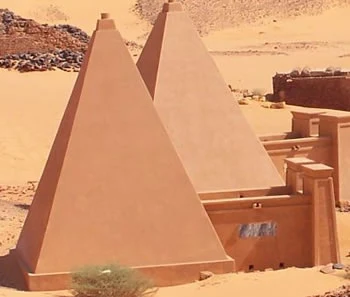
A landscape defined by the Nile and the Nubian desert
Northern Sudan is organized around the course of the Nile and the Nubian desert, on the eastern margin of the Sahara. In the available geographical description, agriculture and livestock farming appear alongside date palm cultivation: a useful context for understanding how the river structures the region, not a guarantee that services or travel are currently available. The Nile and the desert are the clearest references for orienting yourself on the map.
Kush and Meroe: heritage to study before visiting
The northern region gathers references to pyramids, temples, and palaces linked to the ancient kingdoms of Kush and Meroe. Meroe, Musawwarat es-Sufra, and Wad Ben Naqa are among the Meroitic monument complexes mentioned in the research. These are archaeological sites distinct from a living historical city; their interest provides a framework for learning about regional history, not a recommendation to travel under current circumstances. Archaeological heritage should remain a subject for remote study while the crisis persists.
The practical decision: postpone the trip
The travel information consulted describes a civil war in Khartoum and other areas, a humanitarian emergency, and serious risks in parts of the country. Therefore, it is not responsible to present the north, Port Sudan, or another locality as a tourist exception or to propose connections or itineraries. The travel page also warns that access details may change; its data on flights, trains, and routes should not be treated as current services. Postponing means not booking or initiating a tourist trip and reviewing government advisories and official communications if the situation changes.
What to check if the situation changes
Before reconsidering the destination, check your government's travel warnings, the security situation in each planned area, and current communications from authorities and carriers. Confirm separately if there is any legal and operational possibility of access; do not assume that schedules, connections, or routes described in old guides are valid. The Sudan: tourist travel must wait while the conflict continues page gathers the postponement criteria. To locate the country and distinguish general data from changing information, also consult Sudan on the map. Updated verification must precede any travel decision.
Sources and references
Hide references
12 references
References consulted during editorial review. Times, requirements and advisories may change: always confirm with the official source.
-
Northern SudanLicence: CC BY-SA 4.0 Wikivoyage contributors · Northern Sudan
-
Port SudanLicence: CC BY-SA 4.0 Wikivoyage contributors · Port Sudan
-
South SudanLicence: CC BY-SA 4.0 Wikivoyage contributors · South Sudan
-
SudanLicence: CC BY-SA 4.0 Wikivoyage contributors · Sudan
-
Chad - WikiviajesLicence: CC BY-SA 4.0 Wikivoyage contributors · Chad - Wikiviajes
-
Eritrea - WikiviajesLicence: CC BY-SA 4.0 Wikivoyage contributors · Eritrea - Wikiviajes
-
Sudán - WikiviajesLicence: CC BY-SA 4.0 Wikivoyage contributors · Sudán - Wikiviajes
-
Sudán del Sur - WikiviajesLicence: CC BY-SA 4.0 Wikivoyage contributors · Sudán del Sur - Wikiviajes
-
KhartoumLicence: Datos geográficos bajo CC BY 4.0; requiere atribución a GeoNames. Fuente: GeoNames
-
KhartoumLicence: Datos geográficos bajo CC BY 4.0; requiere atribución a GeoNames. Fuente: GeoNames
-
Khartoum, Al Khartum State, SudanLicence: ODbL 1.0; atribución y obligación de compartir bases derivadas. Fuente: OpenStreetMap
